
New article: Calibrating Sentinel-2 imagery with multispectral UAV derived information to quantify damages in Mediterranean rice crops caused by western Swamphen (Porphyrio porphyrio)
Objective quantification of damages caused by conservation interest birds in the rice crops of the Ebro Delta to compensate farmers, based on satellite images and drone. An example of science applied to protected areas management.
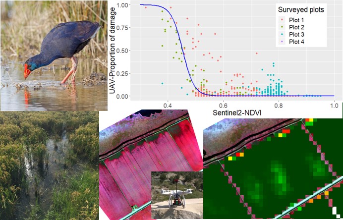
Since 2018, the Catalan Government quantifies in an objective manner the economical compensations received by rice farmers in the Ebro Delta to compensate for the damage caused by Western Swamphen, a bird of conservation interest. Based on the methodology developed jointly by the Inforest JRU group of the CTFC-CREAF and technicians from the Agriculture Department of Catalan Government, with satellite and UAV imagery. This methodology has been published in Drones (MDPI) Special Issue: “Drones for Biodiversity Conservation and Ecological Monitoring”.
Citation: Pla, Magda; Bota, Gerard; Duane, Andrea; Balagué, Jaume; Curcó, Antoni; Gutiérrez, Ricard; Brotons, Lluís. 2019. Calibrating Sentinel-2 Imagery with Multispectral UAV Derived Information to Quantify Damages in Mediterranean Rice Crops Caused by Western Swamphen (Porphyrio porphyrio). Drones 3, no. 2: 45. https://doi.org/10.3390/drones3020045