
SITXELL project awarded with the United Nations Public Service Award.
The SITxell, developed by the Department of Territory and Sustainability (Barcelona Provincial Council), has been awarded with the first UNPSA 2012 price in the category Advanced knowledge management in governments. CONGRATULATIONS!
Together with the Institut Català d’Ornitologia & MINUARTIA, ECOLAND has been, since 2003, helping in structuring and developing the fauna and connectivity works packages of the SITXELL project.
One of the main objectives of the Barcelona Provincial Council is promoting territorial balance and sustainability. In this context, one of the lines of work of the Technical Office for Planning and Territorial Analysis is to improve knowledge of the open areas in the province of Barcelona. The ultimate aim is to provide information and criteria to support local administrations in their land planning and management responsibilities and to strengthen their participation in regional projects affecting them.
Since 2001, Barcelona Provincial Council has therefore been drawing up a territorial information system, the project SITxell (Territorial Information System for the Network of Open Areas in the province of Barcelona), which contains a categorization and assessment of non-urban land based on the analysis of its ecological and socio-economic characteristics.
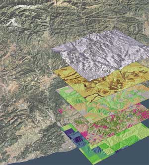
SITxell is a cartographic and alphanumeric database on a 1:50 000 scale, run on Arcgis software, which helps with the study, analysis, evaluation and planning of the open areas in the province of Barcelona. The conceptual basis of this tool lies in the conviction that the open spaces as a whole are the basic territorial system, upon which settlement and infrastructure systems must properly be placed, so that open areas maintain their key ecological and socio-economic functions. It is therefore essential to understand the main features of these areas – both their intrinsic characteristics and the attributes associated with overall processes within the network of open spaces.
On the technical side, SITxell is a project concerning territorial analysis, which is structured through different layers of geographical information and intended to study and evaluate the open areas of the province. On a political level, SITxell is a tool intended to influence land planning processes, on both local and regional scales, by providing accurate and reliable socio-economic and ecological information and criteria for plans and projects developed by the competent authorities. The success and influence of SITxell since its launch have been based, firstly, on the strength and usefulness of the information, applicable in land use planning at different scales and in other specific types of planning (water, agriculture, conservation of habitats and species, strategic environmental assessment, etc.). Secondly, strong partnerships with various levels of government, universities, research centres and private sector (specialized consultants, farmers associations and NGOs) have been established, that have ensured the quality of information and the maximum objectivity of analysis.
————————————-
El projecte SITxell, desenvolupat per l’Oficina Tècnica de Planificació i Anàlisi Territorial de l’Àrea de Territori i Sostenibilitat de la Diputació de Barcelona, ha estat guardonat amb el Primer Premi UNPSA 2012 dins de la categoria Gestió Avançada del Coneixement als Governs.
Conjuntament amb l’Institut Català d’Ornitologia i MINUARTIA, ECOLAND s’encarrega des de l’any 2003 d’estructurar i desenvolupar el mòdul de fauna i connectivitat del SITxell.
Els Premis UNPSA de les Nacions Unides són el màxim reconeixement a nivell mundial de l’excel·lència en el sector públic. De caràcter anual, aquests premis es van establir l’any 2003, i en la present edició del 2012 s’han atorgat en cinc categories diferents i s’hi ha presentat més de 400 projectes de tot el món. El lliurament dels premis va tenir lloc el dia 25 de juny a la seu de les Nacions Unides a Nova York.
El SITxell (Sistema d’Informació Territorial de la Xarxa d’Espais Lliures) és una base de dades cartogràfica i alfanumèrica a escala 1:50.000, elaborada en l’entorn ArcGis, que es va començar a desenvolupar l’any 2001 amb l’objectiu d’ajudar a estudiar, analitzar, valorar i planificar els espais lliures de la província de Barcelona. Conté una categorització i valoració dels sòls no urbanitzables a partir de l’anàlisi de les característiques ecològiques, paisatgístiques i socioeconòmiques d’aquests, i la seva finalitat última és poder disposar d’informació i criteris per tal de donar suport al món local en l’ordenació i gestió del seu territori, i reforçar la seva participació en els projectes territorials que l’afectin. Per a més informació, cliqueu aquí, o bé, consulteu el vídeo.